Case study
Sixth Street Viaduct
Photorealistic, context-driven visuals for an international design competition for a major piece of Los Angeles public infrastructure.
Project at a glance
Photorealistic, context-driven visualization for the international competition to replace one of Los Angeles' most recognizable pieces of infrastructure. Our role was to make the winning proposal clear, believable, and legible at city scale.
- Client
- Michael Maltzan Architecture, with HNTB
- Location
- Los Angeles, California
- Project type
- International design competition
- Building type
- Civic infrastructure, replacement viaduct
- Scope
- One aerial and six contextual visualizations
- Primary focus
- Aerial and city-scale views
- Engagement
- Competition-stage visualization
- Result
- Winning entry, now built and open
The setting
A Landmark the City Could Not Keep.
The Sixth Street Viaduct, originally completed in 1932, was one of Los Angeles' most recognizable pieces of infrastructure. Beyond its Art Deco form, it played a critical role in connecting Downtown LA, the Arts District, Boyle Heights, and the LA River corridor, both physically and symbolically.
By the early 2000s, however, the bridge had become structurally unsound. Alkali-silica reaction in the concrete made it seismically unsafe, and engineers determined that retrofitting was no longer viable. The City of Los Angeles faced a rare challenge: replace a beloved landmark while addressing modern requirements for earthquake resilience, multi-modal transport, public space, and long-term durability.
When the city launched an international design competition, the scope went far beyond rebuilding a bridge. The new viaduct was expected to:
- 01Withstand major seismic events.
- 02Improve pedestrian and cyclist connectivity.
- 03Reconnect communities historically divided by infrastructure.
- 04Activate space beneath and around the bridge.
- 05Redefine LA's relationship with the river.
Michael Maltzan Architecture, working with HNTB, proposed a design that treated the bridge not just as transportation infrastructure but as civic space, a structure meant to be used, occupied, and experienced at multiple levels. Our role was to help make that proposal clear, believable, and legible at city scale.
The challenge
The Imagery Had to Feel Real, Not Conceptual.
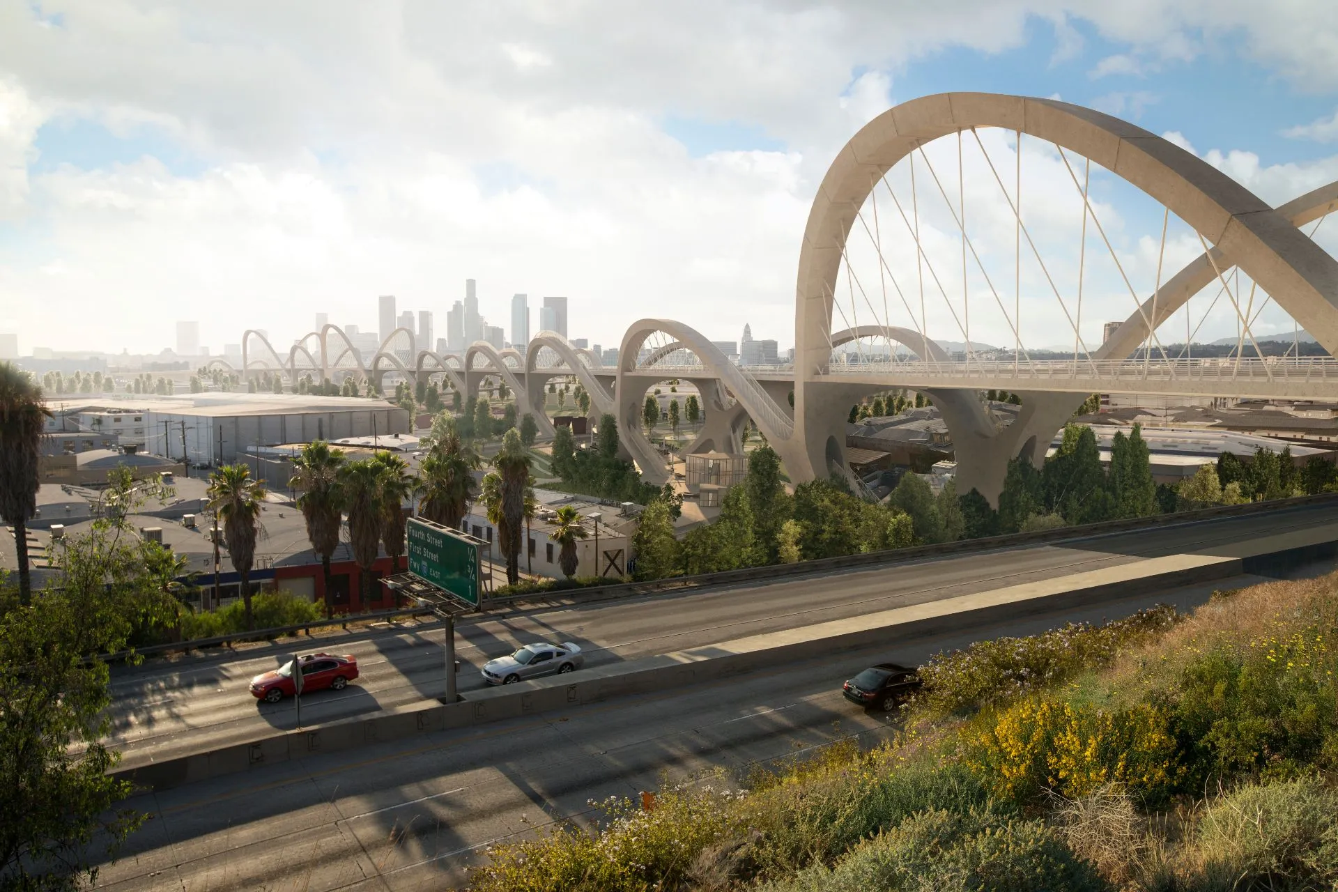
At the competition stage, many proposals relied on abstract or symbolic imagery. Here, that approach carried real risk. Decision-makers needed to understand how the bridge would actually sit within the existing city fabric, how its repeated arches would read across long distances, how light, scale, and structure would shape the spaces below, and how pedestrians, cyclists, vehicles, and public life would coexist.
This was not a purely architectural question, it was an urban one. To succeed, the visuals needed to communicate structural credibility, urban integration, and feasibility at full scale, along with a realistic sense of how the bridge would be experienced day to day.
On the deck
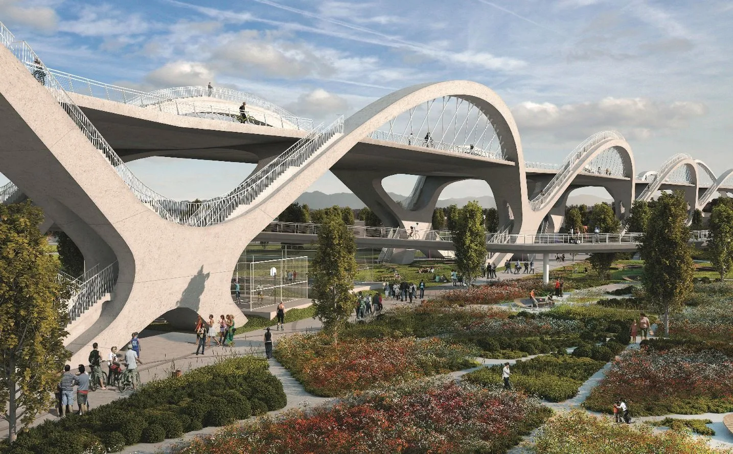
A Civic Space, Not Just a Crossing.
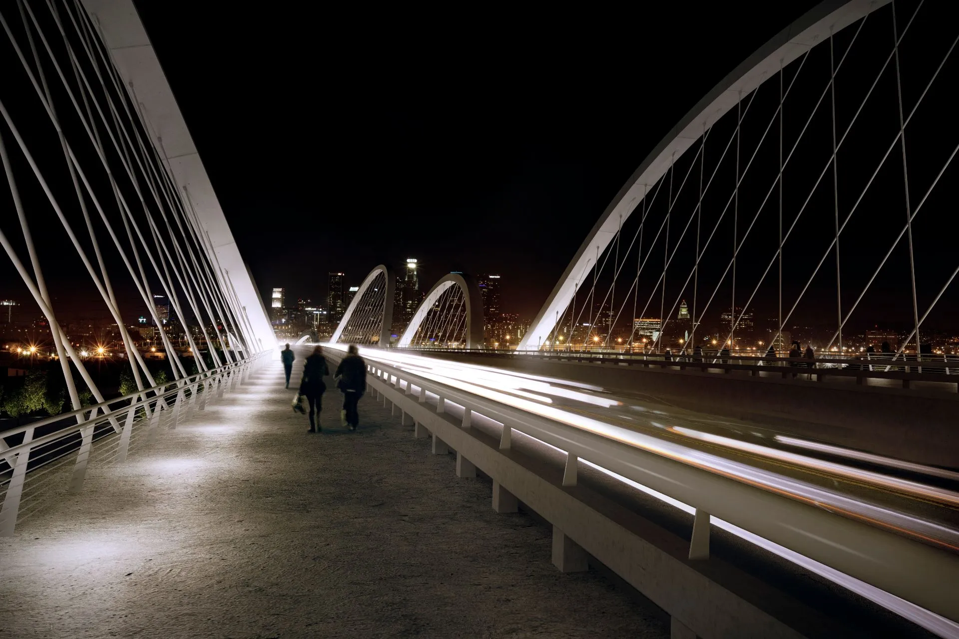
The night views put the viewer on the bridge itself, walking the lit pedestrian deck between the canted arches as traffic streams past toward the Downtown skyline. They were built to show vehicles, cyclists, pedestrians, and public life coexisting on one structure. Rather than selling an idea, the imagery presented a future reality.
The approach
Rendered as if It Were Already Being Built.
Rather than producing speculative visuals, we treated the project as if it were already moving toward construction, and that decision shaped everything that followed. The bridge was placed accurately within Downtown LA, Boyle Heights, the Arts District, and the river corridor, showing how it reconnects neighborhoods rather than simply crossing them, and how it dissolves the divide between East LA and Downtown.
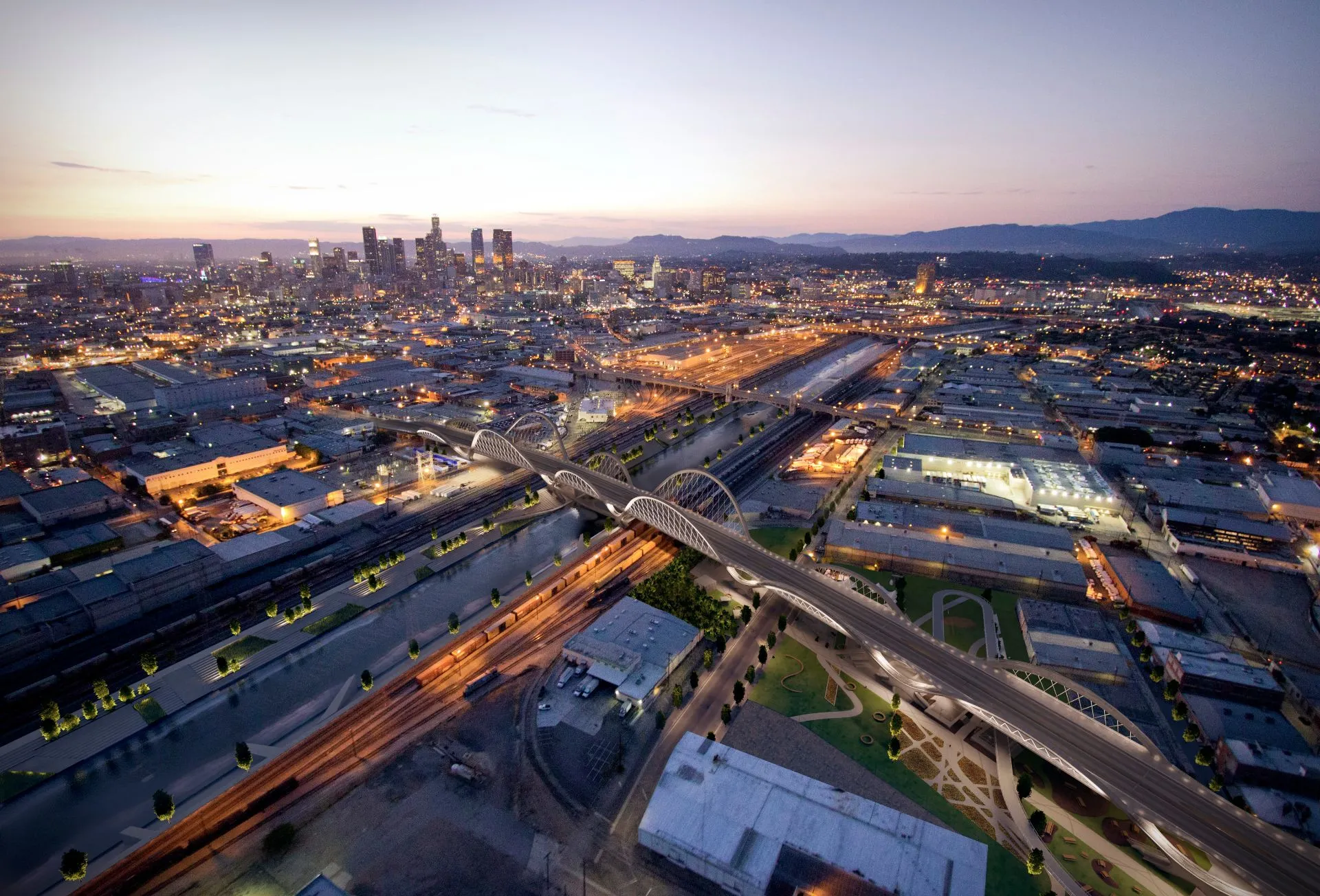
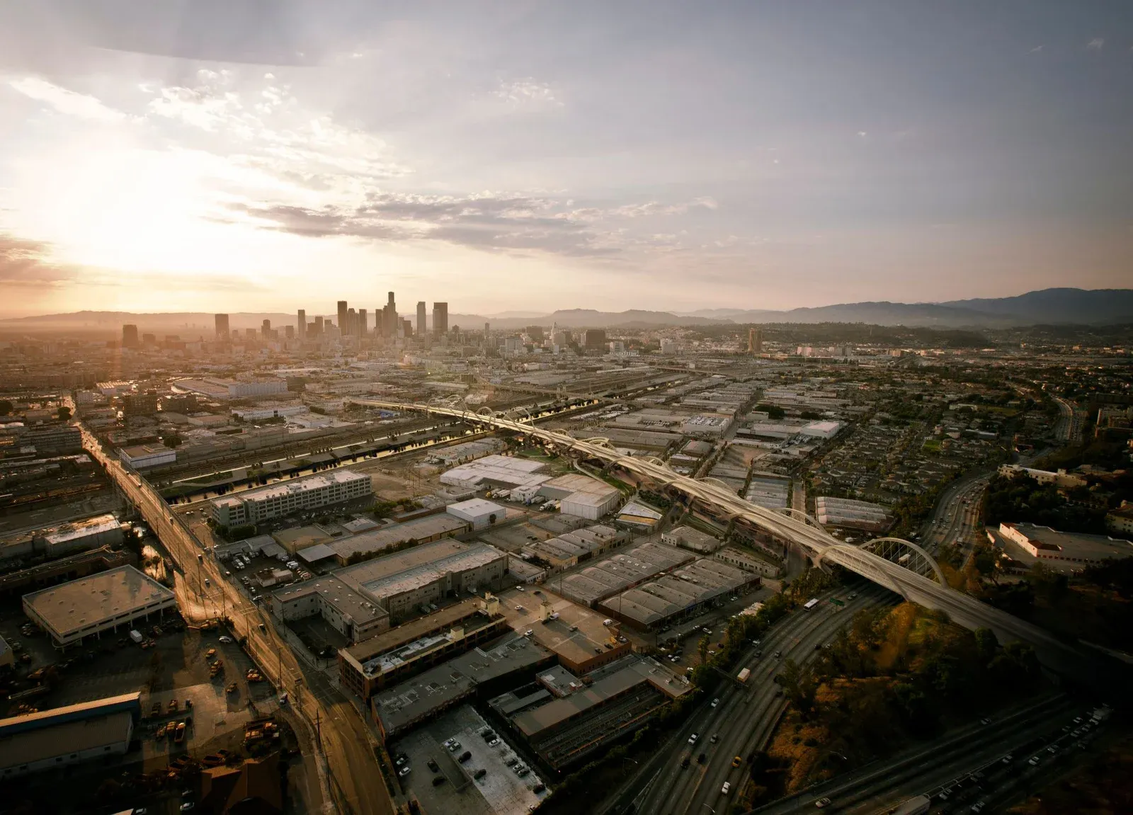
Aerial views emphasized the viaduct's full length, rhythm, and repeated arches, helping reviewers understand the project as a continuous civic element, not a single object. Concrete, structure, and light were represented as they would behave in reality, reinforcing the proposal's seriousness and technical credibility. And the form had to read clearly from afar, across neighborhoods, freeways, and the river, so the bridge could be understood as a new urban landmark.
The set also looked beneath the structure, revealing the spatial potential of the ground plane: parks, plazas, and community use under the arches.
The outcome
The Winning Entry, Now Built and Open.
The proposal by Michael Maltzan Architecture and HNTB was selected as the winning entry of the international competition. Years later, the new Sixth Street Viaduct was completed and opened to the public, now widely recognized as one of Los Angeles' most significant contemporary infrastructure projects: one of the most earthquake-resilient bridges ever built in the region, with expanded pedestrian and cycling access, activated public space beneath the structure, and a new civic landmark for the city. The built result closely reflects the vision communicated during the competition phase.
The project reinforces a principle that continues to guide our work. When visualization is used to reduce uncertainty rather than embellish ideas, it becomes a powerful decision-making tool. For competitions, approvals, and large-scale public projects, clarity builds trust, trust enables approval, and approval allows ambitious projects to move forward.
The Sixth Street Viaduct remains a strong example of how accurate, context-driven visualization can help translate complex urban ideas into outcomes that cities are willing to build.
Questions
Visualizing for a Design Competition
- How does visualization help win an architectural design competition?
- By making the proposal feel real rather than conceptual. For the Sixth Street Viaduct, the imagery was built to documentary accuracy, placing the bridge correctly within Downtown Los Angeles, Boyle Heights, and the river corridor so reviewers could judge how it would actually sit in the city. The Michael Maltzan Architecture and HNTB entry won the international competition, and the built bridge closely reflects the vision shown during that stage.
- Why use aerial and city-scale views for an infrastructure project?
- A bridge is experienced across long distances, so a single eye-level image cannot explain it. Aerial views show the full length, rhythm, and repeated arches at once, letting decision-makers read the viaduct as a continuous civic element rather than a single object, and understand how it reconnects neighborhoods on either side of the river.
- What goes into a visualization package at this scale?
- The Sixth Street Viaduct package consisted of one photorealistic aerial and six contextual views, with the level of accuracy required to present a major piece of public infrastructure as a believable, buildable reality.
Services on this project
Related projects
Start with a discovery call
Eddie Kingsnorth runs the first conversation. The call is where we understand the project and whether we're the right studio to do the work.