Case study
Asbury Park Transit Hub
A Workshop/APD master-plan concept to turn an underused train station into a community and transportation center, given visual form through rendering.
Project at a glance
NoTriangle produced six renderings of Workshop/APD's master-plan concept to transform Asbury Park's underused train station and municipal complex into a mixed-use community and transportation center. The set spans an aerial of the whole vision, the public plaza by day and at dusk, and cutaway sections showing how the district stacks over the rail line. The project is an unbuilt concept.
- Architect
- Workshop/APD
- Building type
- Transit-oriented mixed-use master plan (concept)
- Location
- Asbury Park, New Jersey
- Purpose
- Give a transit-oriented master plan visual form
- Scope
- Six renderings, an aerial, two plaza views, and three building sections
- Status
- Concept, unbuilt
- Engagement
- Part of an ongoing relationship with Workshop/APD
The vision
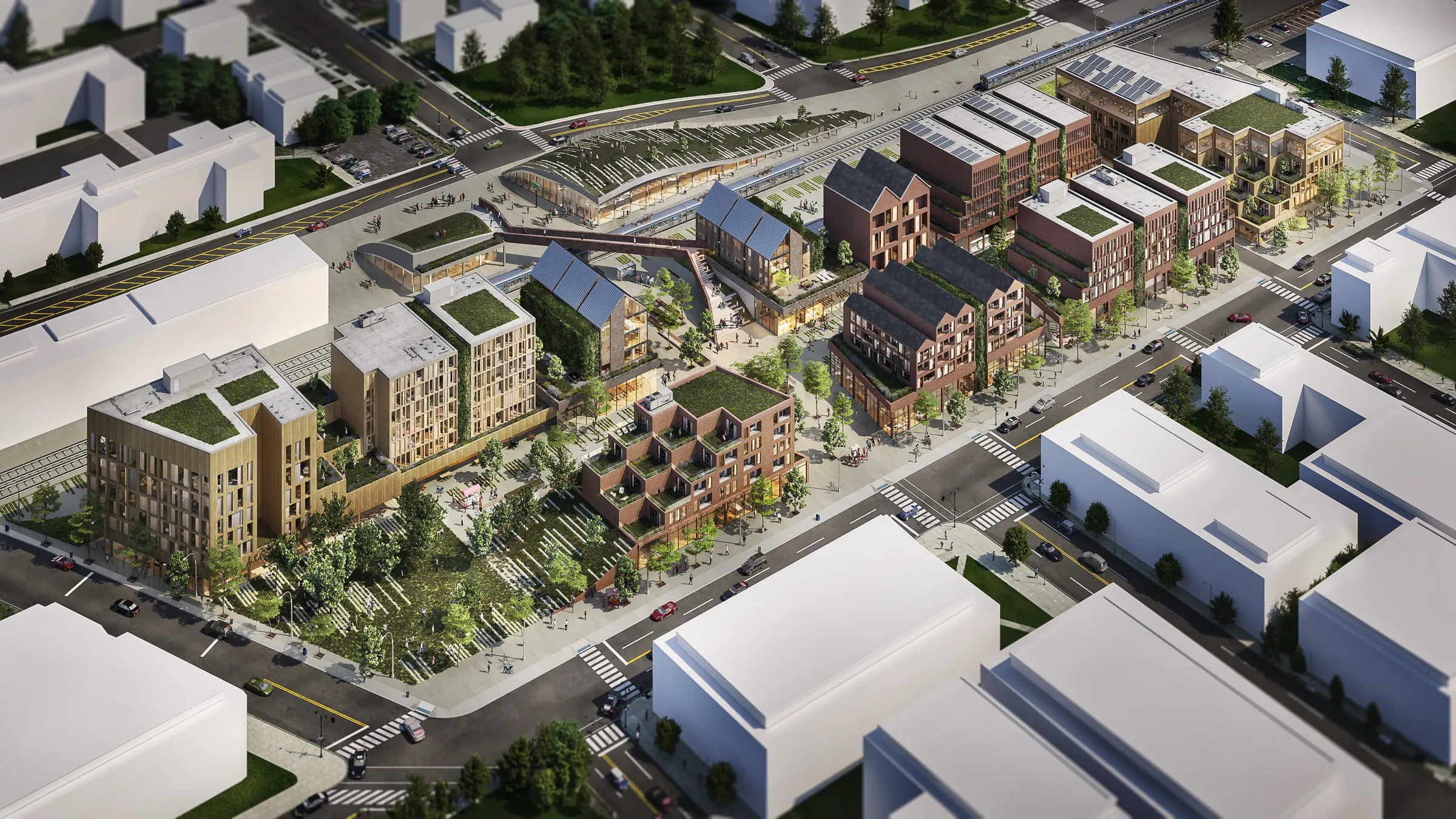
A Station Turned Into a Center.
Workshop/APD's concept reimagines Asbury Park's underused train station and municipal complex, sitting on the dividing line between the east and west sides of the city, as a bustling community and transportation center. The vision knits civic buildings, apartments, a hotel, and retail into a single walkable district, with an elevated public path that bridges the two sides of the tracks and an elevated park, landscaped squares, and green roofs threaded through it.
The idea is as much about the city as the buildings: using the transit hub to reconnect two halves of Asbury Park that the rail line has long kept apart. It is an ambitious, civic-minded master plan, and one that, for now, exists as a design.
The public heart
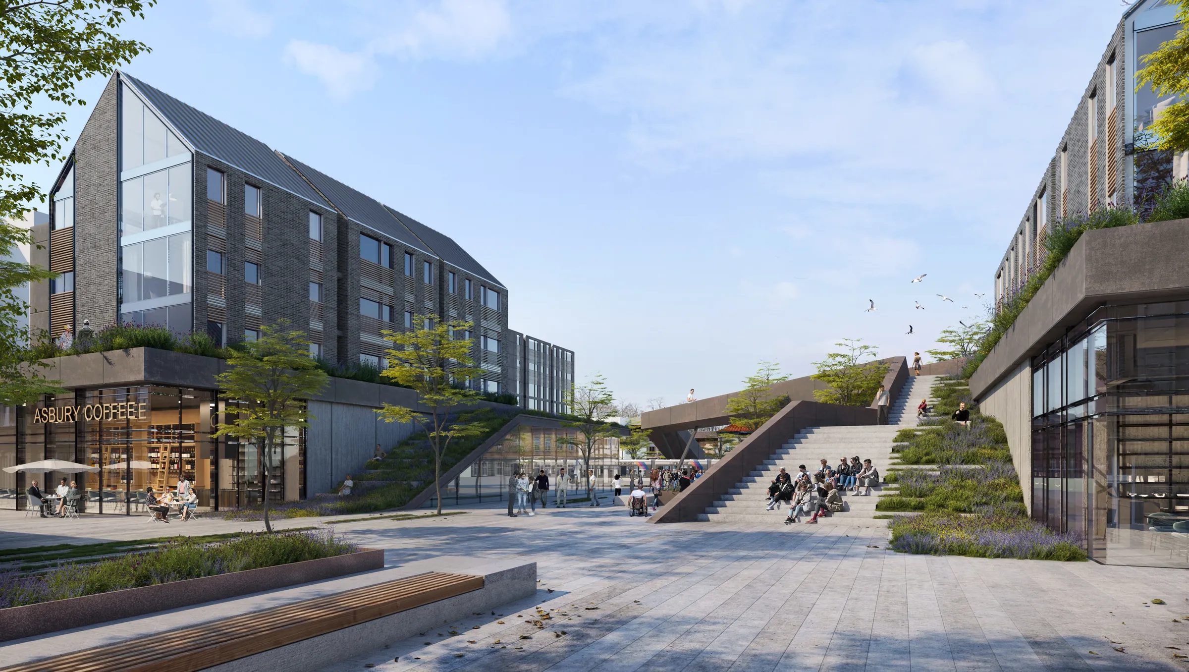
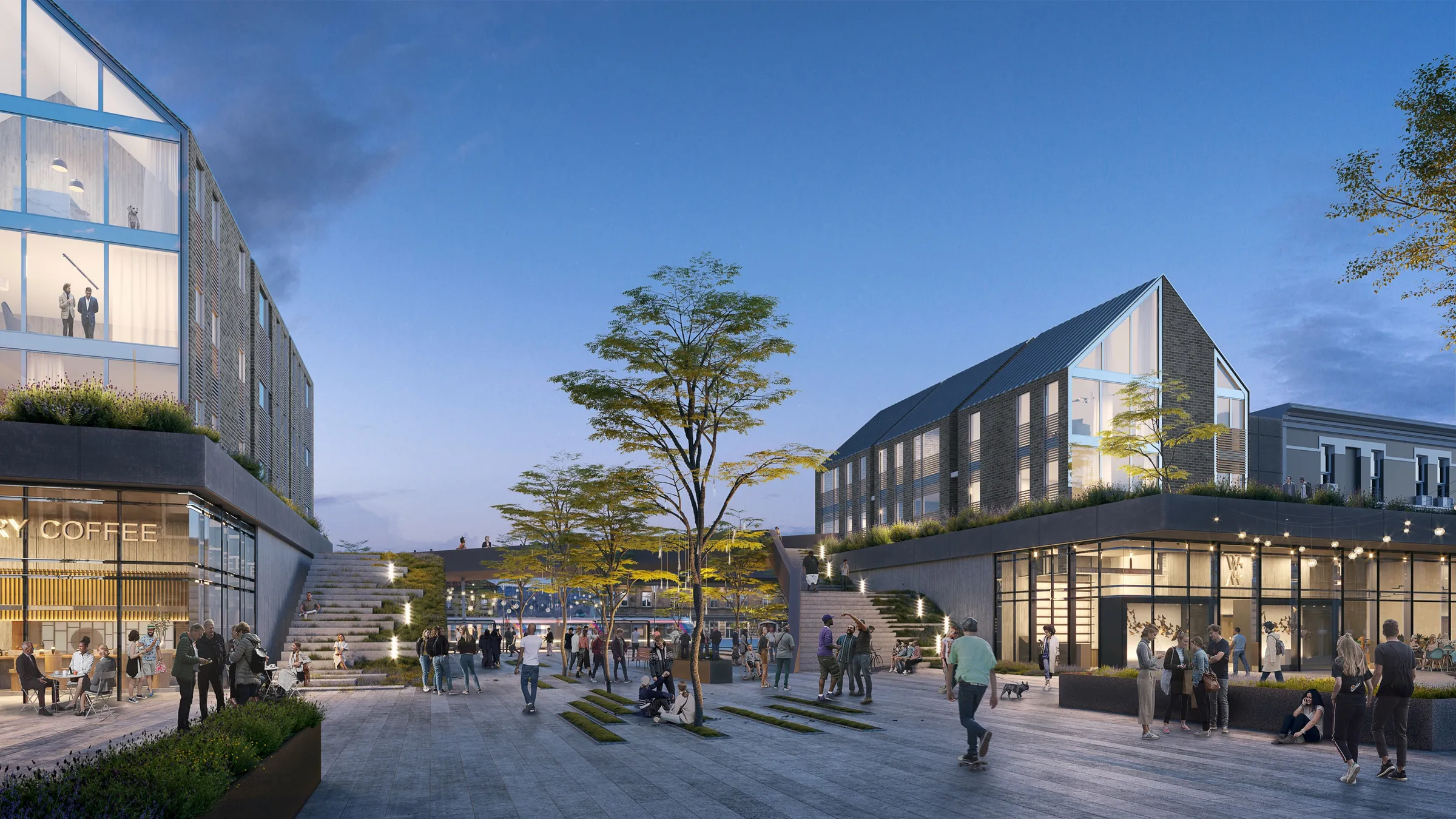
A Plaza People Would Actually Use.
The dusk plaza render is the one that sells the idea: a public square between the buildings, full of people, cafes glowing, string lights overhead. Putting real life into the scene is how a master plan stops reading as zoning and starts reading as a place, somewhere a community would want to gather, eat, and pass through on the way to a train.
How it works
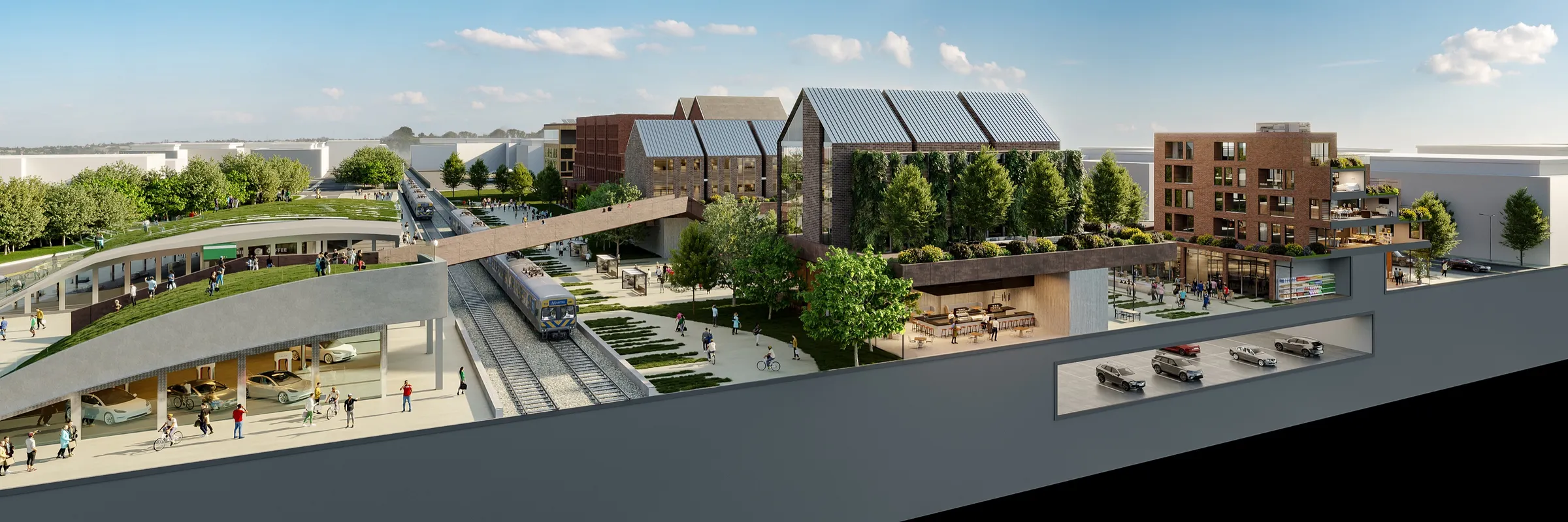
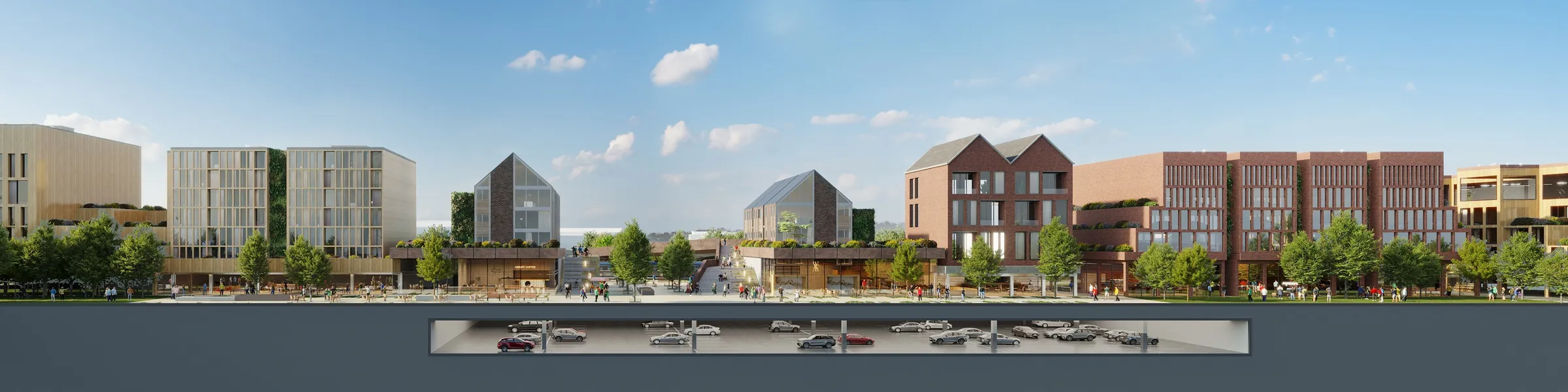
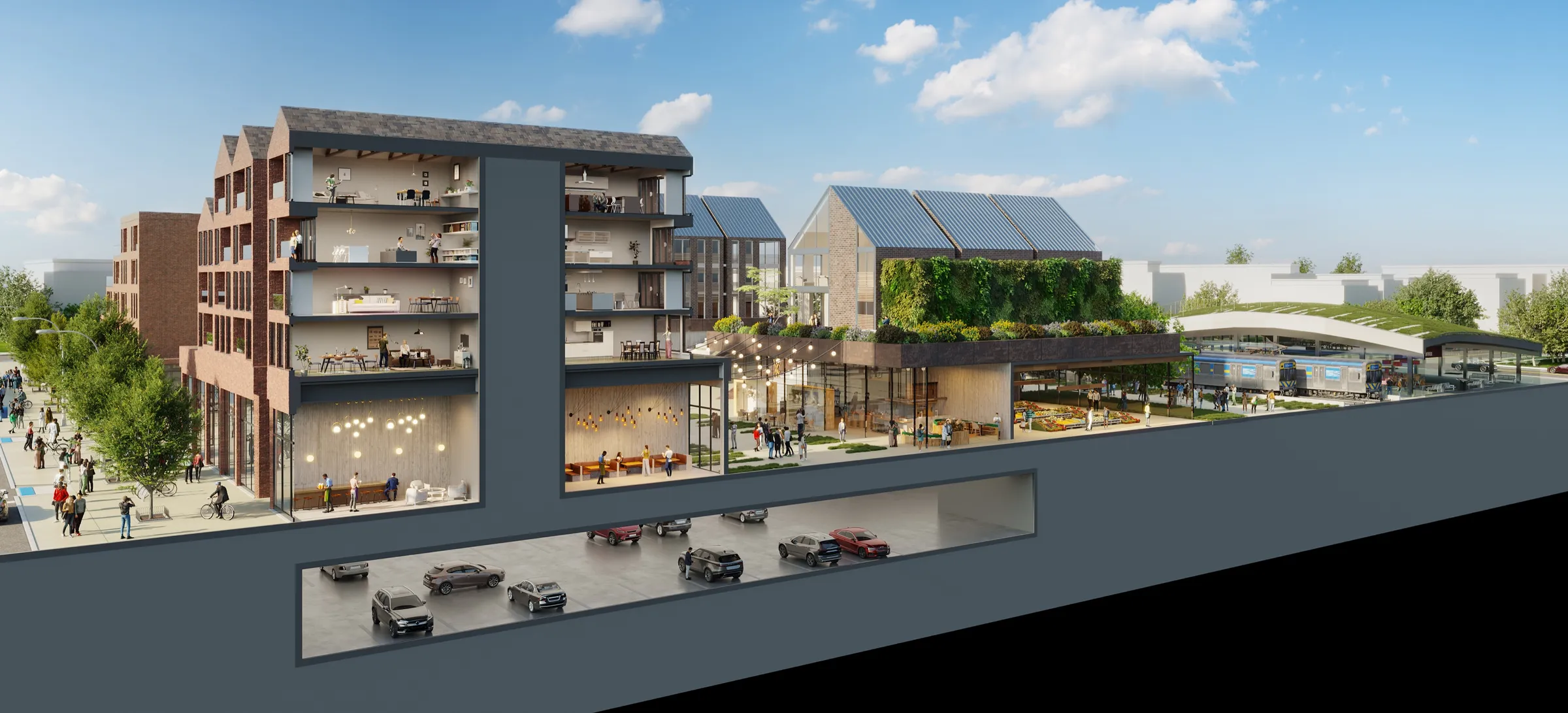
Cut Open to Show the Idea.
The most important images in a master plan are often the ones that explain how it actually works. NoTriangle produced cutaway sections that slice through the district to reveal its layers: the trains and the station platform below, a public deck and the buildings above, and parking tucked underneath and aligned with the structures above it.
These sections, refined model by model with the architect, show the move at the heart of the scheme, lifting a public realm over the rail line so the tracks become something to build across rather than a barrier. They make a complex, three-dimensional idea legible in a single image, which is exactly what a vision like this needs to be understood.
The outcome
A Civic Vision, Made Legible.
The Asbury Park Transit Hub remains a concept, an unbuilt master plan for using a transit station to reconnect a divided city. The renderings are the form the idea takes: the aerial that frames the ambition, the plazas that make it feel real, and the sections that prove it works. For a project that lives as a design, that is the entire job.
The work was part of an ongoing relationship with Workshop/APD, one of the studio's longest-standing architecture partners, a collaboration that has run across residential, hospitality, institutional, and conceptual work over many years.
Questions
Rendering a Master Plan
- What is the Asbury Park Transit Hub concept?
- It is a Workshop/APD master-plan vision to transform Asbury Park's underused train station and municipal complex, on the border between the east and west sides of the city, into a mixed-use community and transportation center. The program imagines a revitalized station, civic buildings, apartments, a hotel, and retail, stitched together by an elevated public path across the rail line. It is an unbuilt concept, and NoTriangle produced the renderings that give the vision form.
- How do you visualize a master plan rather than a single building?
- With a mix of image types, each answering a different question. An aerial shows the whole vision and how it sits in the city; eye-level plaza views show what it would feel like to be there; and cutaway building sections show how it actually works, the trains and station below, a public deck and buildings above, and parking tucked underneath. Together they let people read an entire district, not just a facade.
- Why render a civic concept that is not yet built?
- Because a transit-oriented vision this ambitious has to be seen to be discussed. Renderings turn a master plan into a place people can picture and react to, which is exactly what a community and its stakeholders need in order to weigh an idea before it is funded or built. For an unbuilt concept, the renderings are how the vision exists and gets shared.
Services on this project
Related projects
Start with a discovery call
Eddie Kingsnorth runs the first conversation. The call is where we understand the project and whether we're the right studio to do the work.