Case study
VeLa
Approval-first visualization for high-rise mixed-use towers across six U.S. markets.
Project at a glance
Approval-first visualization built to help planning boards read scale, massing, and context, then move complex towers to a yes.
- Client
- VeLa Development Partners (with Ray as co-developer in Phoenix and Nashville)
- Developer base
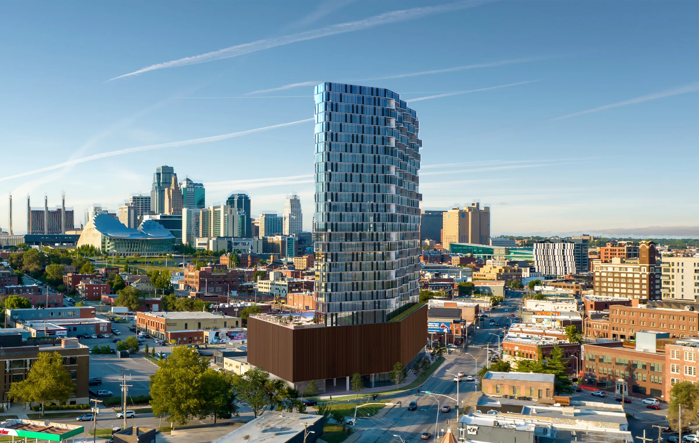
- Kansas City, Missouri
- Type
- High-rise mixed-use rental towers
- Markets
- Tampa, Charlotte, Raleigh, Phoenix, Nashville, Kansas City
- Design partners
- Smallwood (Charlotte, Raleigh), Johnston Marklee (Nashville)
- Scope
- 12 aerial exteriors of five towers in different cities, 10 interiors, and 5 amenity renderings, plus a building animation
- Method
- Drone photography + CGI
- Primary use
- City planning and design review
- Outcome
- Approvals won across markets; Phoenix and Nashville towers topped out
- Engagement
- Multi-market entitlement program
The brief
Six Cities That All Had to Say Yes.
VeLa Development Partners, the Kansas City based rental developer, engaged NoTriangle Studio to produce planning visuals supporting major mixed-use developments across Tampa, Charlotte, Raleigh, Phoenix, Nashville, and Kansas City. In Phoenix and Nashville the towers are co-developed with Ray, the residential brand, and built by partners including Clayco.
Each project involved a high-rise tower with significant urban impact, and each needed a planning board to clearly understand its scale, massing, and integration within a dense downtown environment. The priority was not marketing, it was approval. The visuals had to communicate massing, height, and skyline impact with clarity, demonstrate compatibility with the surrounding neighborhoods, support zoning, planning, and design review submissions, and align multiple consultants into a single, coherent vision.
That called for a visualization partner capable of translating architectural and planning complexity into municipality-ready imagery.

The challenge
Every City Reads a Tower Differently.
Each city presented different review standards, sensitivities, and approval criteria. The projects involved multiple architects and consultants, real-world urban constraints, and extremely high financial stakes, where a delay directly affected financing and construction timelines.
Planning boards required precise, contextual visuals: the street-level experience and pedestrian flow, traffic corridors and sightlines, and each tower's relationship to its adjacent buildings and the public realm. There was no room for generic imagery or interpretation gaps.
The approach
A Planning Exercise, Not a Rendering Task.
We treated the engagement as a planning visualization exercise rather than a rendering task. Each site was analyzed against its local zoning, height restrictions, view corridors, and planning board expectations before a single camera was set. From there, we consolidated inputs from the program's architects, engineers, and consultants, including design firms Smallwood and Johnston Marklee, into unified, consistent 3D assets suitable for public review, so every board saw one coherent version of the project.
To ground each proposal in its real context, drone photography was integrated with CGI, accurately reflecting existing topography, lighting, and urban scale. And because entitlement is iterative, the visuals were refined through multiple board-review cycles, answering feedback with clear scenario studies and updates.
The goal was simple: reduce uncertainty and give decision-makers confidence through clarity.

In the context
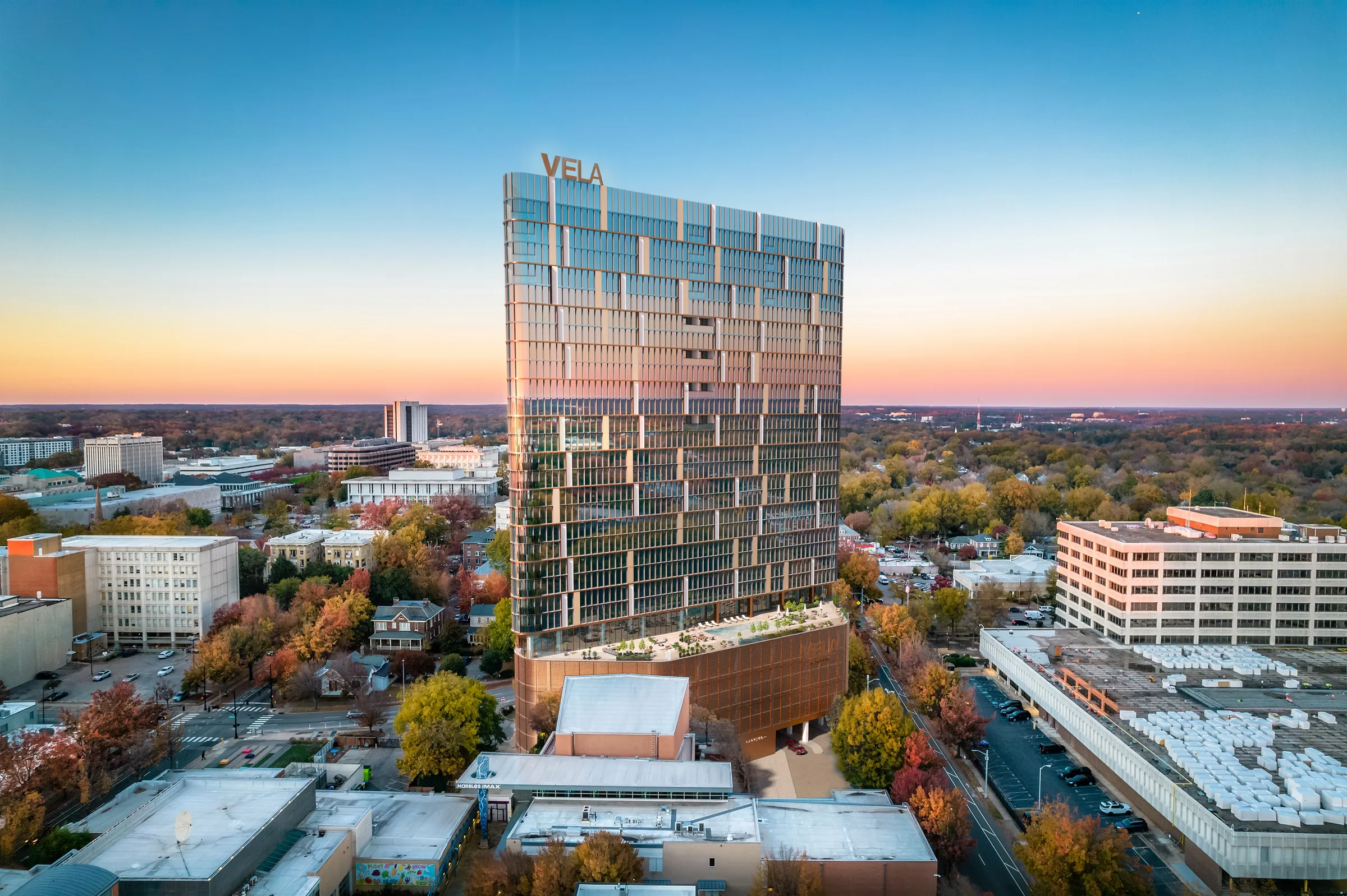
A Tower a Board Could Read at a Glance.
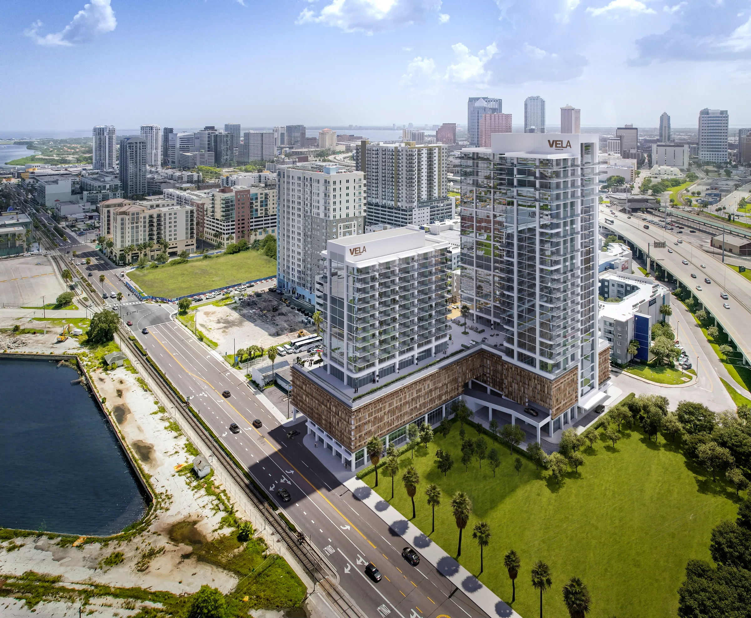
Every tower was shown in its real city, with drone photography and CGI carrying the actual topography, light, and urban scale, so reviewers could judge skyline impact rather than imagine it. In Phoenix, the 26-story, 401-unit Ray Phoenix moved from this kind of review to reality, topping out in 2025 ahead of a 2026 opening.
The results
Approvals Won, Towers Rising.
The planning visuals directly supported successful approvals across multiple cities, and several of those towers have since advanced into construction:
- 01Tampa: two Channel District towers, 27 and 17 stories with 532 apartments, approved following city council review.
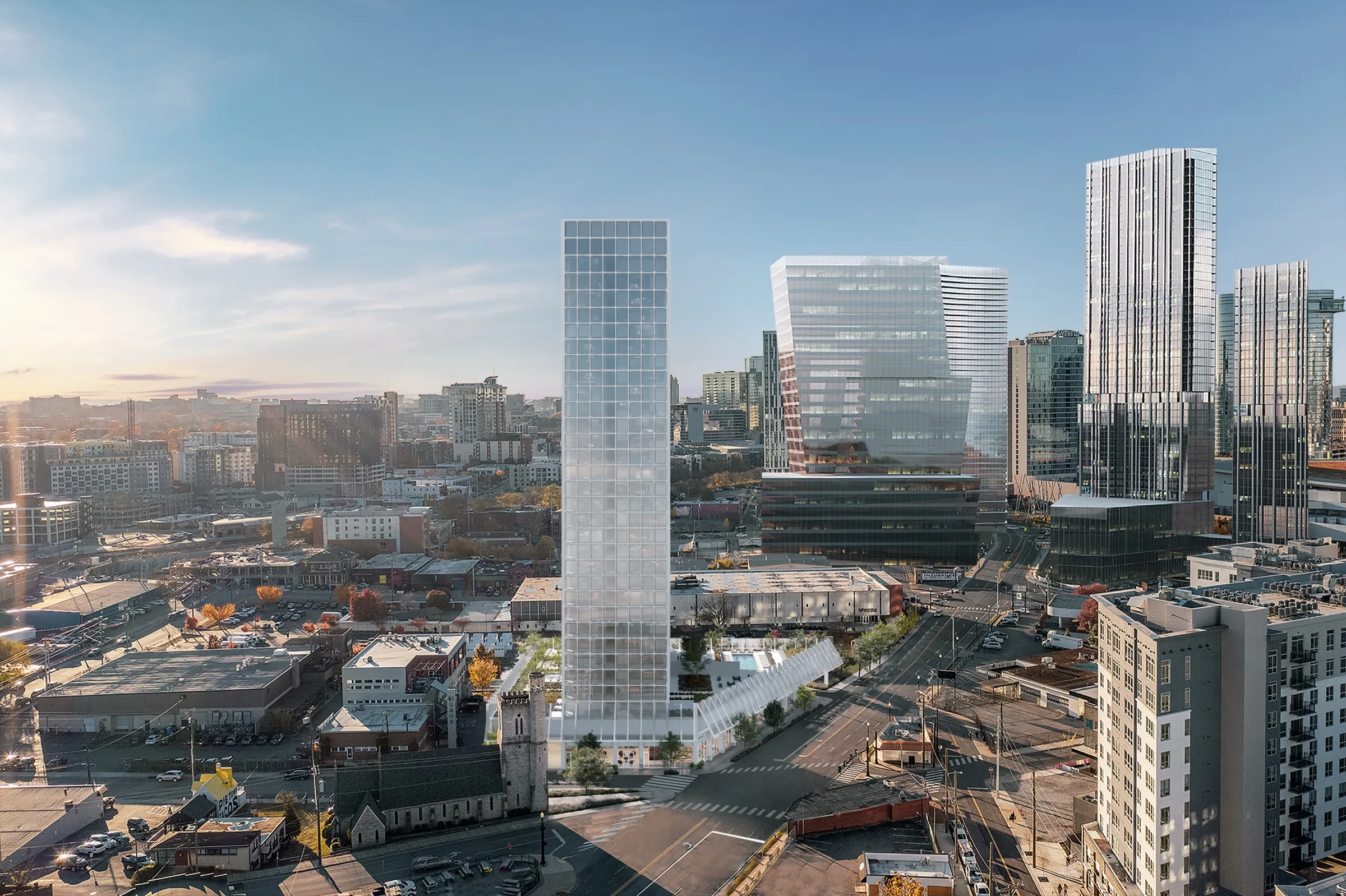
- 02Raleigh: a $170M mixed-use tower approved on the Marbles Museum site (VeLa Longview).
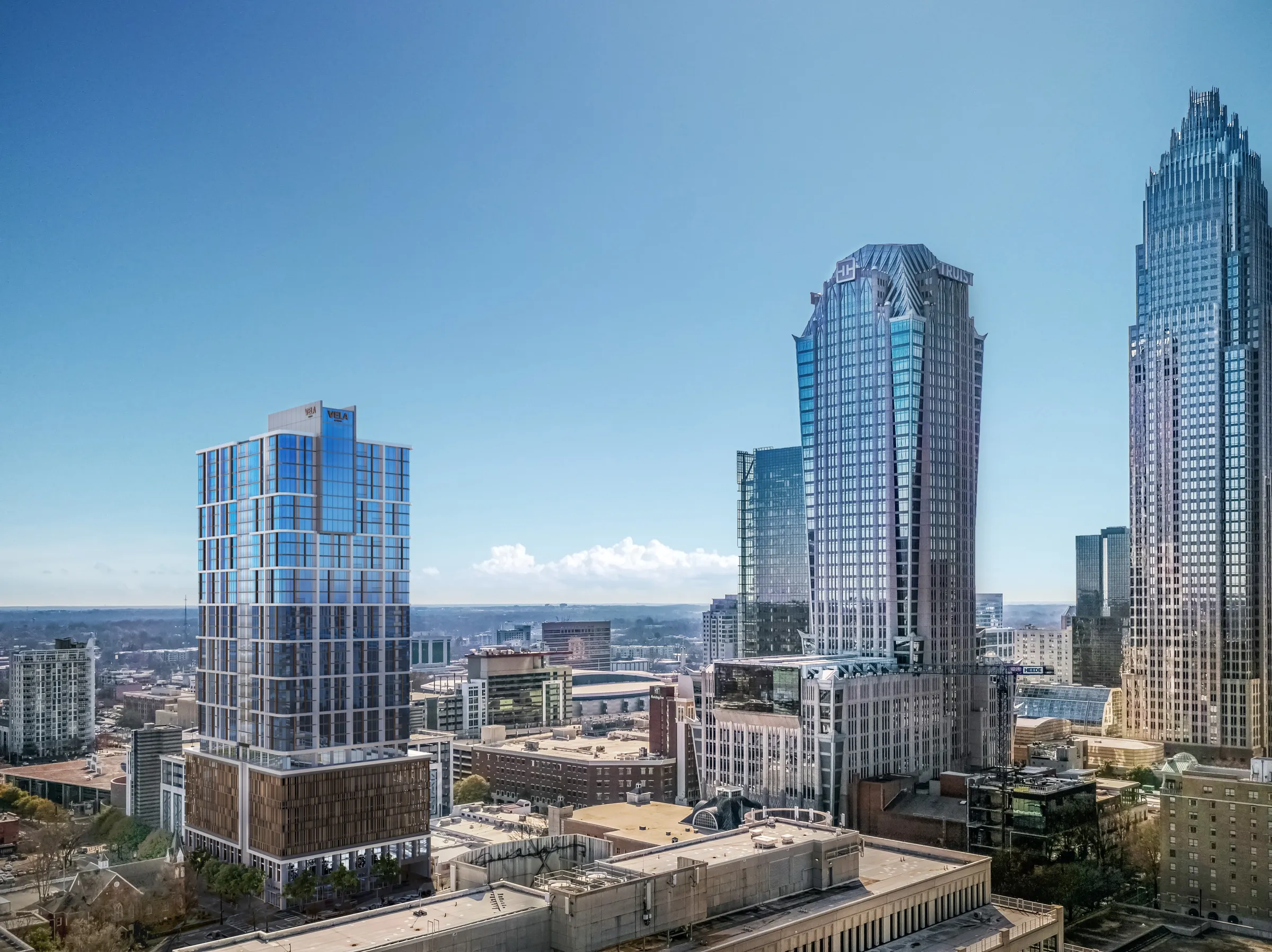
- 03Charlotte: the 32-story, 379-unit VeLa Uptown tower approved on the former Levine Museum of the New South site.
- 04Phoenix: the 26-story, 401-unit Ray Phoenix, built with Ray and Clayco, topped out in 2025 and opening in 2026.
- 05Nashville: the 32-story Ray Nashville tower in Pie Town topped out, opening in 2027.
In each case, the visuals allowed boards to assess impact accurately and move forward without delay.

The outcome
From Entitlement to Construction, Across Six Markets.
The program shows how planning visuals can directly influence the approval trajectory of complex mixed-use developments. City approvals are one of the most critical stages of development, the stage where a delayed yes raises the cost of everything that follows, and it is exactly where clarity pays.
By grounding each proposal in real context, aligning the visuals with planning criteria, and consolidating multi-team inputs into a single narrative, NoTriangle Studio helped reduce risk at that stage across six U.S. markets at once.
The outcome was clear progression, from entitlement to construction and delivery, with the Phoenix and Nashville towers now topped out and moving toward opening.
Questions
Approval-First Visualization
- Can 3D renderings help win city planning and zoning approval?
- Yes. For VeLa Development Partners, the renderings were built specifically for planning boards rather than for marketing, so reviewers could read scale, massing, and skyline impact and assess each tower against local zoning and view corridors. The visuals supported successful approvals across six U.S. markets, including Tampa, where two Channel District towers totaling 532 apartments cleared city council review.
- How do you keep visuals consistent when several architects and consultants are involved?
- We consolidate inputs from architects, engineers, and consultants into a single set of unified 3D assets, so every party reviews the same coherent model. On the VeLa program that meant coordinating across design firms including Smallwood and Johnston Marklee, plus city standards, while keeping one consistent visual language across six markets, the kind of central coordination that prevents a board from seeing conflicting versions of a project.
- What goes into an approval-first visualization program like this?
- The VeLa program spanned 12 drone-integrated aerial exteriors of five towers in different cities, 10 interiors, and 5 amenity renderings, plus a building animation. A multi-market entitlement program at this scale is an investment that is small against the financing and construction timelines it protects, where a delayed approval directly raises the cost of capital on a project worth hundreds of millions.
Services on this project
Related projects
Start with a discovery call
Eddie Kingsnorth runs the first conversation. The call is where we understand the project and whether we're the right studio to do the work.